Aerial photography
Showing the contiguous site boundary and links to Le Thi Rieng, Le Van Khuong, Ha Huy Giap and National Highway 1A.
In preparation
Site dossier
A 6.99 ha site at the northwestern gateway of Ho Chi Minh City
A single contiguous parcel of 69,880.75 sqm fronting Le Thi Rieng Street in Thoi An Ward. All Land Use Right Certificates are held by a single legal entity. The 1/2000 zoning plan has been approved by the Ho Chi Minh City People's Committee.
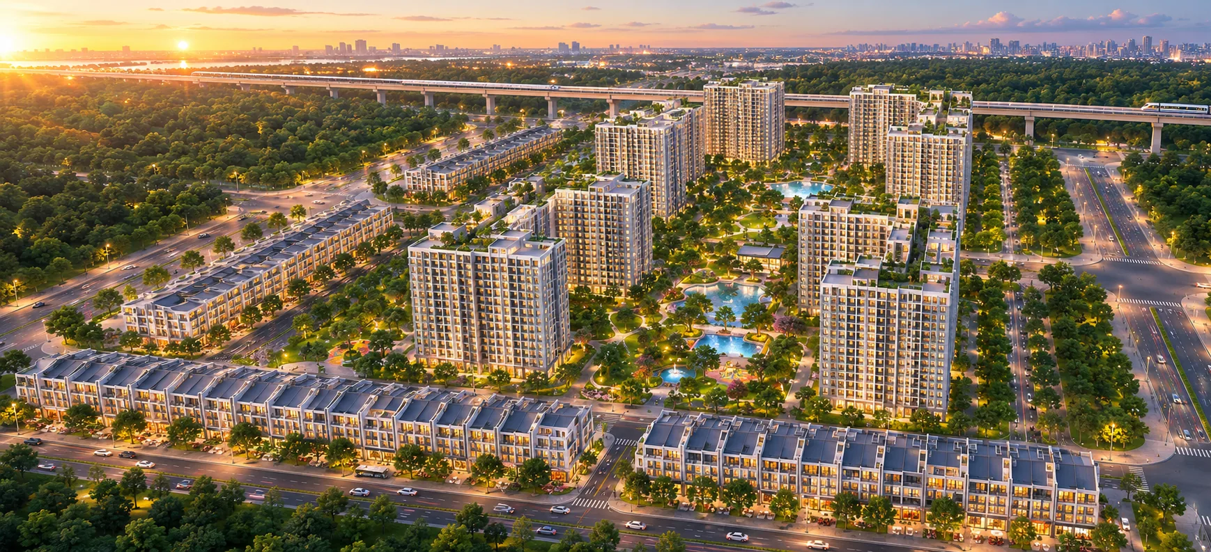
Illustrative visualisation · Study scheme
The site
The site was consolidated under a single legal entity over many years. It is currently vacant and undeveloped.
| Project name | Thoi An Luxury |
| Location | Le Thi Rieng Street, Thoi An Ward, Ho Chi Minh City |
| Total area | 69,880.75 sqm (approx. 6.99 ha) |
| Planning designation | Mixed-use residential development: high-rise apartments, a commercial podium, low-rise housing, plus social infrastructure including a school and an internal park, under the 1/2000 zoning plan |
| Registered holder | The entire site is held by a single legal entity, not split across multiple owners |
| Current status | Vacant, undeveloped |
Site boundary shown on satellite imagery. Click the image to enlarge.
Zoning
Figures follow the approved 1/2000 zoning plan, with more than a quarter of the area allocated to schools, parks and social infrastructure.
Figures follow the 1/2000 zoning plan approved under Decision No. 3903/QD-UBND dated 17 November 2021.
Legal
All Land Use Right Certificates for the site are held by a single legal entity.
The Ho Chi Minh City People's Committee issued Decision No. 3903/QD-UBND approving a local amendment to the 1/2000 zoning plan for the District 12 Centre and Residential Area (Zone 2), Thoi An Ward, covering blocks III.1 and III.16.
Decision No. 4151/QD-UBND on the Ho Chi Minh City Housing Development Plan for 2021-2025, which includes the project in Thoi An Ward.
Connection agreements are in place for water supply, drainage, power supply and height clearance.
Written approval has been obtained from the Department of Natural Resources and Environment.
Extract from Decision No. 3903/QD-UBND dated 17 November 2021, Ho Chi Minh City People's Committee. Document is in Vietnamese. Click to enlarge.
Location
Aerial view of the area. Labels are in Vietnamese. Click the image to enlarge.
Connectivity
Direct links to National Highway 1A and Le Van Khuong Street give convenient access to the centre.
Connected via Ha Huy Giap Street, the main corridor towards the Binh Duong gateway.
A bypass route relieves the National Highway 1A and Le Van Khuong junction.
Travel times are indicative and vary by time of day and traffic conditions. Labels are in Vietnamese.
Amenities
All essential amenities are already operating nearby, with no need to wait for new investment.
Regional links
The area acts as a bridge between Ho Chi Minh City and Binh Duong, Tay Ninh and the south-eastern provinces via National Highway 1A.
Di An (part of Ho Chi Minh City) and the former Thu Duc City
Former Binh Tan District and former Binh Chanh District
Former Go Vap, Tan Binh, Tan Phu and Binh Thanh Districts
Former Hoc Mon District and Thuan An (part of Ho Chi Minh City)
Area context
On 1 July 2025, Thanh Xuan Ward was merged into Thoi An Ward under Resolution No. 1685/NQ-UBTVQH15. The site belonged to Thoi An Ward both before and after the merger. The name "District 12" is retained in this dossier as a familiar geographic reference to the northwestern gateway of Ho Chi Minh City.
The area sits on National Highway 1A, the arterial corridor linking central Ho Chi Minh City with Binh Duong, Tay Ninh and the south-eastern provinces.
Formed from communes of Hoc Mon District and established as a district in 1997. Previously farmland with a sparse population before urbanisation.
From 2000, urbanisation accelerated and drew both domestic and foreign investment. The Tan Binh and Tan Thoi Hiep industrial parks were established alongside infrastructure expansion.
One of the most densely populated urban areas in Ho Chi Minh City, with markedly improved infrastructure and strong growth in retail, services and education.
Expected to remain a priority growth area, tied to new infrastructure and urban projects over 2026-2030.
Four main road corridors are already in operation, surrounding and directly serving the area.
The backbone corridor linking the western area to central Ho Chi Minh City, Tan Son Nhat Airport and the key economic zones.
The inter-regional trade corridor heading northwest, connecting Tay Ninh and major industrial parks.
Connects Go Vap, District 12 and the Binh Duong gateway, extending the urban footprint to the north.
Connects District 12 and Hoc Mon, relieving the Nguyen Anh Thu corridor and National Highway 22.
State-funded infrastructure works that directly affect connectivity in the area.
| Status | Project | Details |
|---|---|---|
| In operation | An Suong Underpass (2020) | Total investment of approximately VND 514 billion. At the National Highway 1A and 22 junction, two underpass branches create a three-level interchange, easing congestion at the northwestern gateway. |
| In operation | An Phu Dong Steel Bridge (December 2020) | Connects Go Vap and District 12, shortening travel times to the centre and to Binh Duong. |
| In preparation | Vam Thuat Bridge | Total investment of approximately VND 1,136 billion, of which more than VND 800 billion is for compensation and site clearance. A new bridge replacing the deteriorated An Phu Dong steel bridge, opening a direct link from An Phu Dong to the centre. The investment policy submission is expected in Q3 2026. The feasibility study is scheduled for preparation and approval from Q4 2026 to Q2 2027, with construction expected to start in Q4 2027 and completion targeted for 2029. |
The An Suong interchange has been in operation since 2020, linked to the site via National Highway 1A.
Metro Line 4, running from Dong Thanh to Hiep Phuoc, is a cross-city public transport spine linking the northern area to the centre and the south of the city.
Dong Thanh to Hiep Phuoc. The line follows the planned Dong Thanh and Thanh Xuan corridors, then Ha Huy Giap, Nguyen Oanh, Truong Son, Nguyen Van Troi, Hai Ba Trung, Le Loi and Tran Hung Dao, heading towards the Hiep Phuoc port urban area.
The line follows the planned Thanh Xuan and Ha Huy Giap corridors. Since 1 July 2025, the Thanh Xuan area has been merged into Thoi An Ward, the same ward as the site.
In early August 2026, geotechnical drilling began along the route to assess ground conditions. The project is completing its feasibility study and investment preparation procedures. The feasibility study is targeted for completion in 2026, with construction expected to start in Q1 2027 over an estimated five-year build period.
Network diagram as previously planned. The Line 4 alignment has since been revised. Labels are in Vietnamese.
Media
Aerial photography, video and the VR360 survey are being prepared.
Showing the contiguous site boundary and links to Le Thi Rieng, Le Van Khuong, Ha Huy Giap and National Highway 1A.
In preparationOn-site aerial footage, professionally edited and narrated.
In preparationWith hotspots at the site boundary, street frontages and main connecting corridors.
In preparationDevelopment direction
At 6.99 ha in a single contiguous parcel with mixed-use residential zoning, the site can support a self-contained township with integrated social infrastructure. The direction outlined below is based on market research and infrastructure trends for 2029-2031, and is indicative only.
Vietnam's national Net Zero 2050 pathway. Ho Chi Minh City targets a fully electric bus fleet by 2030. Over 2029-2031, home charging points are expected to become as essential as broadband internet is today.
Circular No. 31/2026/TT-BXD sets the first dedicated rules for EV charging areas in apartment buildings, effective 15 December 2026. Existing buildings must complete a review by 15 June 2027, whereas newly designed schemes can build the requirements in from the start.
Green-certified development is encouraged and supported by local authorities. Schemes that follow this route tend to move more smoothly through approvals and to access green credit lines more readily.
Serving the household while allowing the charger to be shared during idle hours through a professional operator.
Resident priority through licence plate recognition, combined with a solar canopy. Operated by a professional provider under service and safety commitments.
Located at amenity points across the township. A full battery in a few minutes with no waiting to charge, suited to electric motorbikes.
Under the code effective 15 December 2026, EV charging areas must form a separate fire compartment and be fitted with automatic fire detection, automatic suppression and CCTV linked to a 24-hour monitoring room, regardless of floor area. They must also carry CO and HF gas detectors, the gases released when a lithium-ion battery fails. A new design can incorporate all of these requirements from the basic design stage.
The 22 visualisations below sketch out the township under the study scheme. Click any image to enlarge.
The scheme is organised around a central landscape spine with a lake and generous planting. Close to 27% of the area is given to social infrastructure and green space, which keeps building density low and puts schools, parks and internal amenities within walking distance.
Charging points sit along the low-rise frontage from the infrastructure design stage rather than being retrofitted later. Carriageway widths and parking bays are sized for cars that charge regularly, instead of following an older residential template.
Owners charge at their own door, with no trip to a basement and no queue. The charger can also be shared during idle hours through a professional operator, turning technical infrastructure into a source of income.
The fast-charging hub sits beside the park, so residents plug in and walk rather than wait in the car. Licence plate recognition gives residents priority, visitors pay a commercial rate, and that revenue helps fund landscape maintenance.
The canopy is also a solar array, shading the cars while offsetting part of the electricity used by the chargers beneath it. One element doing two jobs, and an easy point to make when pursuing green building certification.
Charging is placed outdoors rather than concentrated in an enclosed basement. This follows Ministry of Construction guidance on fire safety for charging areas and eases the load on basement ventilation.
The central hub serves day and night, run by a professional operator under safety commitments. The scheme contributes the infrastructure, the partner contributes the equipment, and both share the revenue and the risk of technology becoming obsolete.
Electric motorbikes are the most common vehicle in a residential area. A swap station provides a full battery in minutes and takes significant load off the charging points during the evening peak.
The basement charging area is separated and designed to the new safety code, rather than a few isolated points scattered through a shared car park. This is an element that schemes designed before 2020 can rarely retrofit.
A multi-layer fire protection system for the charging area, with an on-site team trained at regular intervals. For a homebuyer this delivers a reassurance that convenience alone cannot.
An outdoor café sits next to the charging hub. Fifteen minutes waiting for the car stops being dead time and becomes part of the daily routine, and a place where residents meet.
The station never closes, which suits residents who leave early and return late. No waiting to charge, and no calculating how much range is left in the day.
A children's playground, a café and outdoor seating sit between the buildings. Shared space is what turns a collection of apartments into an actual community.
A landscaped lake, open lawn, walking paths and a playground sit at the heart of the scheme. Children running outside and adults exercising in the morning are what make a residential area somewhere worth living, not just somewhere to live.
Consistent lighting along the street, wide pavements and a charging point at every door. Evening is when a residential area reveals most clearly what living there is like.
A planted entrance gate, a wide approach road and landscaping on both sides. This is the first thing visitors and residents see each day, and it shapes how the whole scheme is judged.
Chargers are designed to the scheme identity, becoming a piece of visible infrastructure rather than plain equipment. A small detail, but one repeated across the site often enough to read as consistent.
The lobby is the first touchpoint each day and the first thing a visitor sees. Ceiling height, materials and lighting here largely determine how the whole scheme is perceived.
The lift takes residents straight to their own floor and stops strangers reaching residential levels. It is both a convenience and a layer of security that runs in the background.
Open views over the internal park and the northwestern skyline. The balcony becomes an extension of the living space rather than somewhere to hang laundry.
Lighting, air conditioning, blinds and door locks run through a single control panel. An open connectivity standard lets residents add devices from other brands without being locked into one ecosystem.
Duplex shophouses in the podium with food and beverage outlets and a children's play area. Residents have amenities at the foot of the building, and operators have a steady captive customer base from day one.
All images in this section are indicative visualisations under the study scheme, not approved designs.
Contact
Legal documentation and detailed materials are provided on request. Please leave your contact details.